Saturday, September 3, 2011

Olympic National Park--Three In One


There is more to Washington than its infamous volcano. In the state's northwestern corner, quite outside of the crabby St. Helen's reach, stands a mountain range that has never witnessed smoke plumes nor worn mud-blast scars. It is called Olympic.

Unlike the Cascades, the Olympics are not old volcanoes. Born of mud and sand, then glaciated into a tangle of peaks, the rugged domes rise sharply above the Olympic Peninsula. Grandeur preserved. For the highest and harshest of these mountains lie within the 1,400 square miles known as Olympic National Park.

Though nearly circled by U.S. 101, the park itself is 95 percent roadless. Ten spur roads lead for short distances into the interior; none cross its wilderness. This park will forever belong to the one willing to walk and its more than 600 trail-miles can be hour, day, or week segments.

THE LAND OF GREEN TWILIGHT

The Hoh Rainforest
Three of the spur roads on the park's west side follow along the Quinault, Queets, and Hoh river valleys, penetrating the creme-de-menthe maze called rain forest. The Quinault and Queets roads are mostly gravel, unsuitable for trailers. Upper Hoh River Road is paved. All areas offer campgrounds, trout fishing, and rare sights of the park's Roosevelt elk.

Summer months on the valley floor are usually fair and warm as the heaviest precipitation--145 inches annually--falls between October and March. The abundant rain, combined with the mild coastal winters, has produced an optimum forest, unequaled on this continent.

Naturalist, Roger Tory Peterson said, "...the Olympic rain forest contains the greatest weight of living matter, per acre, in the world." It  must be so for it is near impossible to find one square inch of soil not supporting life. Spruce, hemlock, fir, and redcedar dominate the realm, with a vast understory of deciduous trees and shrubs.

Mantles of thick clubmoss upholster everything in sight, creating an emerald world mostly devoid of sound. Light is diffused from leaf to vine to fern until even the air seems tinged with green twilight. Little wonder this coniferous kingdom was the determining factor in UNESCO's decision to declare Olympic National Park a World Heritage Site. Forests like this will never be common again.

SAND AND SEACLIFFS

Ruby Beach
The park's seacoast strip is one mile wide and fifty long. Within that stretch are two campgrounds, two Indian Reservations, a world reknown archaeological dig, and a coastline labeled one of the wildest in the nation.

The entire strip lacks development and is practically roadless. The southern portion is easily accessible with U.S. 101 paralleling 12 miles of shoreline from Kalaloch to Ruby Beach. Access roads at the strips mid-point lead to the Hoh and Quileute Reservations and at the colorful Indian village of LaPush, salmon charters are plentiful. The season usually runs from May through August, with no license required.

Both Kalaloch and Mora-Rialto Beach afford lodging, dining, and camping. The area harbors a horde of razor clams along with crab, smelt, and surf fish. Though a license is not needed, all are subject to season and limit.

Toward the strips northern end lies Cape Alava, the most westerly point in the contiguous United States. Centuries ago mud slides buried the Makah village built here. Since 1970, Washington State University archaeologists, in conjunction with the Makah Tribe, have excavated this 500 year-old "Pompeii in mud." Today, the Ozette Archaeological Project conducts free tours, interpreting the site's history.

SEA LEVEL TO SKI LEVEL

Hurricane Ridge
Two spur roads just east of Port Angeles bring the interior Olympics within easy view. The road to Deer Park is mostly one-way dirt; Hurricane Ridge Road is well paved two lane. Deer Park offers camping; Hurricane Ridge does not. Yet both areas provide sweeping panoramas of glaciered peaks, sloping meadows, whaleback ridges, and ice-honed valleys.

Hurricane Ridge is popular summer and winter. Approximately 30 minutes from Port Angeles via the park's main Visitor Center and Pioneer Museum, the summit rises from sea level to ski level. Road's end consists of a parking area, hiking trails, picnic areas, and a day-use lodge featuring light meals, gift shop, and authentic Indian crafts.

December to April, the ridge provides weekend skiers with full facilities. Memorial Day to mid-September, it is a painter's palette of wildflowers, meadow grasses, and gnarled firs.

Because the Olympics are not a true mountain range, the 180 degree southward view is one of jagged peaks apparently having no rhyme or reason. Seeming more a jumble of sawtoothed pinnacles, they lie smothered in unfathomable snow and ice.

There are more then  60 glaciers on these mountains, covering an area in excess of 25 square miles. Most are not as large as those on near-by Mt. Rainier. Some are bigger than any within Glacier National Park.

Northward vistas revel the Little River Cirque, Port Angeles, and the Strait of San Juan de Fuca with Vancouver Island across the channel--sometimes clearly visible; most often fog-shrouded.

Within Olympic's wilderness miles, mountain goats scale the crags and marmots dine amidst flower fields. Black bear prowl coastal tidepools and bald eagles soar out to fish. Waves continue crashing against the cliffs and spindly-legged sandpipers scoot along the spindrift. Sea clouds billow inland, dropping their staggering rainfall. Tumbling streams and rivers return the moisture seaward.

Times here seems little changed. Within the diversity of Olympic's undeveloped expanse, the life-cycle continues. Neither searing mud blasts nor ash storms have fractured the fragile eco-system. In this snug corner of Washington, the web remains unbroken.

Sunday, August 21, 2011

On The Trail Of The Ancients

There is no better time to tour the American
Southwest than Fall and Spring when the days
are comfortable and the nights cool enough
for sleeping.
There is a great hunk of the American Southwest that is commonly called canyon country, principally because major rivers like the Colorado, Little Colorado, and the San Juan have sliced it through, dissecting its red rock walls and amber mountains into a tangle of twisted canyons.

The Navajo who have long inhabited this rugged country say it is "the land of room and time enough." Some inventive Chamber of Commerce people named it Four Corners after the spot where Utah, Colorado, New Mexico, and Arizona come together. Geologists simply refer to it as the Colorado Plateau.

Whatever its title, this place of long horizons, rocky cliffs, hot sand, and thorny plants claims an unusual treasure: strewn across its many mesa tops and tucked inside its innumerable alcoves are hundreds of crumbling cities--sandstone wonders that are but the skeletal remains of an ancient civilization that rose, flourished, and then disappeared.

This is the land of the Anasazi. The Ancient Ones. A plateau people who walked softly across the land, going from the nomadic life of hunters and gatherers to the sedentary ways of farmers, artisans, and basketmakers. They were an inventive and adaptable people who devised intricate irrigation systems, coaxed vegetables out of desert sand, and wove baskets so tightly that even today they will still retain water.

But most of all they were builders in stone, laying down on plateau bedrock self-contained worlds that clustered close around rivers and streams. But they were never to last. In the end, the Anasazi mysteriously abandoned their homes, leaving them to the capriciousness of desert winds, parching sun, freezing winters, and the ghosts--silent sentinels who still walk among the rocks, keeping vigil over the great ruined cities.

The mesa top homes and cliffside dwellings have weathered well. Many are so finely preserved it seems their inhabitants have only just stepped out and will return momentarily. Others fall back into the earth from which they came, as hauntingly beautiful in death as ever they must have been in life.

Some are easily accessible; others require long, dusty rides over washboard roads. But all are unique and en masse they constitute the greatest collection of prehistoric archaeological sites in North America. Rich is the one who follows the trail of the Ancients, moving back through the years to savor the character of a people who in their own short time cast a giant footprint across the land.


CHACO CANYON NHP in northwestern New Mexico was the Anasazi's great cultural center. Within a 32 square-mile area are 2,000 prehistoric sites that once accommodated approximately 7,000 people. The park itself contains 40 small ruins and 12 large pueblos, with the most expansive being Pueblo Bonito, a Chacoan community that sprawled across three acres, contained 800 rooms and 28 kivas (underground ceremonial chambers), housed about 1,000 people, and in its time was probably the largest single prehistoric structure in the Southwest. The park is open year round and has a small campground.

MESA VERDE NP in southwestern Colorado is our only national park devoted entirely to the works of man. It was here that the Anasazi art of building in caves reached its highest level. The park contains many of the largest and most famous cliff dwellings in the United States--700 year old apartment houses that have survived the centuries largely intact.

Some of the ruins are self-guiding; others accessible only in the company of a park ranger. The cliff dwellings themselves are spectacular, though getting to them in often entails climbing down ladders bolted to sheer cliffs, squeezing through narrow paths hewn in solid rock, and crawling on hands and knees through slim-cut tunnels. Those not so ambitious can enjoy the mesa top ruins. The park is open year around and provides full services from May through mid-October.

NAVAJO NM in northeastern Arizona contains three elaborate cliff dwellings abandoned more than six centuries ago. Known today as the Kayenta Anasazi district, these ruins combine with those of Chaco Canyon and Mesa Verde to form the third major area where the Ancients prehistoric culture flourished. The monument is open year around. Because all park ruins are fragile, they can only be accessed in the company of a ranger and reservations are required. Be warned. The trip down into the canyon is strenuous. This view is from the Visitor Center.

CANYON DE CHELLY NM in northeastern Arizona encompasses all stages of Anasazi growth, from the earliest Basketmaker pit houses to the masonry marvels called Pueblos. The steep-walled Canyon de Chelly (prounounced d' Shay) and its adjoining Canyon del Muerto contain several hundred prehistoric villages that date from A.D. 350 to 1300. A paved road along de Chelly's south rim leads to five overlooks as well as the trailhead to White House Ruin, the only self-guiding trail in the park. The park is open year around and maintains a small campground.

HOVENWEEP NM straddles the Utah-Colorado border and the 504 acre park contains some of the finest freestanding Anasazi stonemasonry still intact. The monument envelopes six ruin-clusters, each with a preponderance of square, oval, circular, and D-shaped towers that display expert masonry and engineering. Other than a few small peepholes, the towers are windowless and it has been suggested that their sole purpose was to confound those who came later. The name Hovenweep is Ute, meaning "deserted valley." The title is apt. Except for a few small trading posts scattered here and there, the scrub-covered terrain is largely uninhabited. The park is open year around and claims a small campground.

The Ancients carved images on rocks and
the petroglyphs are just about everywhere
you look. Some say they are maps, some
claim they tell of good hunting grounds. The
fact is, no one knows for sure. Defacing
them is a crime.

Although Anasazi villages stretched north to Glen Canyon and Canyonlands, west to Zion and Grand Canyon, and south to Petrified Forest, the Ancients were not the only prehistoric culture that walked the beige sands of the semi-arid Southwest. To the north were the Fremonts; to the south, the Sinagua. Southeast lived the Cohonino; southwest the Mogollon and Hohokam. Each culture followed much the same path as the Anasazi and whatever the reason or reasons, all began abandoning their villages about the same time, with most being completely deserted by A. D. 1300.

The dry, desert climate has itself acted as the preservative--saving for all generations a time-warp into yesteryear. Thousands of prehistoric Indian ruins dot the Four Corners states. Most are under the guardianship of the National Park Service and while every adult I know will enjoy the ruins, nobody has as much fun as the kids. My own kids loved visiting the ruins; my granddaughter, at age 7, just plain stood in shock with unbelieving eyes as she caught her first view of  Montezuma's Castle in Arizona. The fun for me was always watching them take it all in, knowing they'd never before seen anything like it. I still remember my granddaughter standing speechless, mouth agape, and finally asking "Grandma, how did they get into their houses? They built them so far off the ground."


Montezuma's Castle in Arizona stunned
my granddaughter into silent awe. It
was the first of the Indian ruins we had
taken her to see. She always claimed the entire
trip had been a great adventure.

Tuesday, August 2, 2011

Lighthouses--Sentinels Of Our Shores

Many lighthouses still welcome visitors. Call first to check days and hours. Then go and enjoy. Climb a spiral staircase. Examine a Fresnel lens. Watch the world from a lantern tower. Listen for the ghosts of days long past. Then pass on the lore, lest someday you be asked the same question my six-year-old granddaughter asked me when she said, "Grandma, what's a lighthouse?"


They stand at the outer limits of civilization, stalwart sentinels whose distinct shapes stud all manner of seagirt rocks, treacherous ridges, wind-pummeled sandspits, and ever-eroding promontories. By day they are landmarks. By night they are beacons that puncture the darkness. But always they are silent guardians that warn of offshore rocks, shifting shoals, and perilous reefs.

They are America's lighthouses, sea-based signposts that stand where fogs cling and gales howl. Their origin dates back to 280 B. C. when  the Egyptians constructed the Great Pharos of Alexandria, a 400-foot high light tower so magnificent it became one of the Seven Wonders of the World. Lighthouse history in America had its roots in Boston Harbor where, in 1716 the first New World light tower took form on Little Brewster Island--with the cost of maintaining the light paid for by taxing all merchant vessels moving in or out of the harbor a penny per ton for services rendered.

Notwithstanding the need for lighthouses on American waterways, there were but 12 to be handed over to the newly established Federal Lighthouse Service in 1789. They were not alone for long. More and more light towers began studding our coasts, rivers, and lakes and what followed was the era of the "wickies", those faithful keepers who polished brass, trimmed wicks, and kept the lamps glowing.

In 1939 the U.S. Coast Guard assumed responsibility for lighting our shores and as technology increased, more and more lighthouses were automated and every entrance locked tight. Many others were abandoned, their 19th Century heyday overshadowed by aero beacons atop 20th Century steel. A few were turned into museums, historic attractions, and privately-owned inns. Whatever their status, all remain as intriguing as the scenic places in which they stand--and all captivate the wayfarer with histories as colorful as their legion of legends.

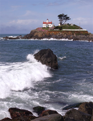
THE BATTERY POINT LIGHTHOUSE--ENDURANCE IN EVERY EXPOSURE

Accessible only at low tide
Admission fee
It was one of the original 16 West Coast lighthouses and so sturdily constructed that even today, more than 140 years after it was built, the small stone and masonry house with its red-roofed light tower remains virtually unchanged. Quite a feat since the structure is such an easy target for Pacific storms--sitting as it does atop a tiny islet just 300 yards off the mainland of Crescent City, California.

Surrounded by the sea during high tide, and washed on three sides at low tide, the Battery Point Lighthouse has proven its endurance in every exposure, though never so well as in March of 1964 when it stood fast against a seismic tidal wave that ravaged 56 square blocks of Crescent City.

"We clung to one another," says the journal of Peggy Coons, wife of (then) keeper Roxey Coons, "and prayed that God would have mercy on us. Roxey shouted, 'let's head for the tower,' but it was too late. The wave struck, split, and swirled around both sides of the island with such speed we felt like we were sailing right along with it. Everywhere we looked was a shambles: houses, buildings, lumber, boats, all smashed or moved blocks from where they had been. It still seems hard to believe," she concluded, "that of all the salvage that floated by us, the only bit to reach the island was one spool of lavender thread."

THE BANDON LIGHTHOUSE--SURPRISES IN THE NIGHT

Though the lighthouse is in near
ruins, it retains the mystique of
yesteryear. One of my all-time
favorite lighthouses.
The lighthouse is empty and the tower dark. Swallows fly in and out the open door; seabirds circle overhead; incoming tides dash themselves to death on the rocks along the Coquille River's north jetty--site of the Bandon Light.

Built in 1896, the pyramidal structure served as both a seacoast and harbor sentinel, warning mariners away from what was considered to be the most dangerous bar in all Oregon--the Bandon Bar, site of more than a few tragic shipwrecks.

 But even with the lighthouse in working order, there were still some surprises afloat: the C.A. Klose floundered in heavy seas; the Advance got lost in the fog. Both, albeit on separate occasions, ended up on the lighthouse doorstep. But the tales end well. No one was hurt, the schooners were repaired, and the Bandon Light went down in history as one of the few lighthouses ever hit by a ship.

THE POINT REYES LIGHTHOUSE--FACTS STRANGER THAN FICTION

Entrance is by way of Pt. Reyes
National Seashore
It isn't bad enough that the light tower sits at the far end of a desolate, nearly roadless slab of land just 50 miles north of San Francisco or that the skies are sunny one moment and fog-shrouded the next, or that the winds blow with a constancy that could change the purest saint into a wild-eyed maniac. It isn't even bad enough that the light lies along California's infamous San Andreas Fault. What really takes the cake are the more than 300 steps down to the light tower and what seems like at least 600 back up.

Beset by problems since its 1870 inception, the Point Reyes Light claims a history as riveting as any television docu-drama.: In 1872 the fog signal building burned to the ground; in 1874 an assistant keeper clambered down the cliffs to investigate a wrecked ship and was never heard from again; in 1887 the the station was reputed to be the windiest and foggiest on the West Coast (since verified by the U. S. Weather Bureau); in 1889 an assistant keeper went crazy and had to be handed over to the constable in nearly Olema; in 1916 winds in excess of 100 miles per hour took down fences, poles, chimneys, and the tank house roof. And all the time, despite the light tower, fog signals, life saving station, and radio beacons, ships continued to leave their bleaching hulls on the ragged reefs around Point Reyes. Who says facts are boring?

THE YAQUINA BAY LIGHTHOUSE--GHOSTLY BUSINESS

Once my granddaughter heard
the ghost story, she refused to
continue the tour. Gramps took
her outside; I did the tour alone.
Admission fee.
"In the hush of late afternoon came a shriek so piercing those who heard it froze in their tracks," says the lighthouse host as she recounts the disappearance of Muriel Trevenard. "And although the girl's friends looked for her everywhere, all they ever found was a warm pool of blood and a stained hankie. It's said that her ghost still haunts the upper chamber."

A foggy day and an old lighthouse hidden behind tall trees are an unshakable combination--if you want the hairs on the back of your neck to come to attention. Never mind that the lighthouse was built in 1871 and used only three years. What's important is that after it was abandoned it fell into a state of disrepair--and everyone knows mysterious goings-on always happen in spooky old places.

Well, take heart. The lighthouse has been completely refurbished with period pieces; the banisters shine; the windows gleam. Surely no self-respecting ghost would live in such light-bright surroundings. But then again, no ghost has ever lived here. For the tale of Muriel Trevenard is pure fiction, written by Lischen M. Miller and published in 1899 by Pacific Monthly.

Turns out the lighthouse guides love to tell the ghost story. "They like to get people wondering," the Assistant Manager told me. What most of them miss is the twinkle in their eyes when whispering the tale to a group of sightseers. Twinkle? You could have fooled me. What I saw was fear.

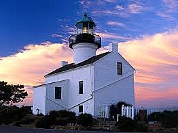
THE OLD POINT LOMA LIGHTHOUSE--PACIFIC PATRIARCH

The Lighthouse is accessible via
Cabrillo National Monument at
the tip of Point Loma. Admission fee.
The Monument itself is one of San
Diego's best whale watching sites.
In 1885 it was the highest elevation lighthouse in the nation. Today it is the most visited. Situated at the tip of Point Loma in San Diego, the two-story structure was not only one of the first West Coast lighthouses, but the southernmost along the edge of the (then) newly acquired California coastline.

It was a patriarch whose lamp remained lit for 36 years. There was, however, one insurmountable flaw: high fog often prevailed along this section of the coast, and although the shoreline itself was generally clear, the 462-foot high Point Loma headland was usually obscured. And so was the light. So in 1891 the old lighthouse was abandoned in favor of a new one closer to the water.

By 1913 the deserted lighthouse was so deteriorated and abused it was scheduled to be razed. "Not so," cried a citizen's group. "This San Diego landmark should be preserved." And so it was. Restored it is mid 1800s appearance, the Old Point Loma Lighthouse became a favorite tourist attraction. In 1933 it was handed over to the National Park Service as part of Cabrillo National Monument.

It still stands--a tiny lighthouse set on a hill. Useless? Maybe. But the view from the tower is still one of the most magnificent anywhere-- because on a clear day you really can see almost forever.

CAPE DISAPPOINTMENT LIGHTHOUSE--THE FIRST THAT FINISHED LAST

Cape Disappointment Lighthouse
is in Ilwaco, WA. Entrance is
through Fort Canby State Park.
Admission fee.
So treacherous were the ever-shifting sandbars at the mouth of the Columbia River that in 1853, when Congress funded the first eight West Coast Lighthouses, they gave Cape Disappointment in Washington state top priority. Here, on the river's northern edge, would stand the Pacific's first beacon of safety. But it was not to be. The bark, Oriole, loaded with men and supplies fell victim to the very ship-eating shoals they'd come to warn against, and although the men escaped with their lives, the vessel and its cargo were a total loss.

It was 1854 before a second load of supplies reached the Cape and another two years before the first-order Fresnel lens began casting its guardian eye seaward. The lighthouse that was to have been finished first, instead, finished last.

It still stands. And below its time-worn portals lies a century of history, for here, where waves erupt and sandbars wait, are the skeletal ribs of countless small vessels, at least 200 deep water ships, and the watery graves of 1,500 men. No wonder they wanted a lighthouse here. And no wonder this place has gained a reputation as the "graveyard of the Pacific."

America's lighthouses stand on some of the most cruelly exposed spots imaginable and, en masse, are such marvels of engineering that even now, more than a century later, we are awed by the obvious courage and ingenuity of those who risked life and limb to fashion guideposts for a trackless sea. I have featured but a few West Coast lighthouses, but there are many more scattered along every large waterway in our nation.


For more information on West Coast Lighthouses, contact the U.S. Lighthouse Society in San Francisco. For Great Lakes lighthouses, contact the Great Lakes Lighthouse Keepers Association in Allen Park, MI. For some great photos of all our nation's lighthouses, click on this link: Lighthouses By State This is a site rich in lighthouse history and even notes those lighthouses that are for sale. If you buy one, let me know. I've always wanted to stay in a lighthouse.

While you're out seeing America this summer, stop by a lighthouse to be a part of what was. Show your kids and grandkids history they'll always remember. My granddaughter was 6 when we took her on our lighthouse trip. She still remembers it vividly and someday, will pass on what she's learned.


Monday, July 25, 2011

Wyoming's Terrific Tetons

The Valley of the Snake River in Grand Teton National Park. Because my son lived in Wyoming for so many years, my husband and I saw this park in every season. Spring weather was still chilly and winters are just plain cold. Summers are hot and tourist-packed, but autumn is most agreeable. Peasant days are accompanied by cool nights, perfect weather for snuggling in a sleeping bag.


There is no way to prepare the senses for the awesome reality of the Teton Range. Likening it to other mountains is inaccurate, photos lack dimension, and descriptions fall short. So imposing is their presence that first-time onlookers are stunned into slack-jawed unbelief.

Many mountains are higher; most are longer. But few explode from the earth as do the Tetons, rising straight up to stand 7,000 feet above the grass and sagebrush flats of Wyoming's Jackson Hole. It is one of the boldest spectacles on the American earth. Little wonder its rugged beauty is forever preserved within the 485 square miles of Grand Teton National Park.

Compared to most of our parklands, Grand Teton is small. But don't let its size fool you. Here are concentrated grandeur--mountains, lakes, valley, and river all oozing with more scenery, more wildlife, and more history than many parks twice its size.

Much is visible through the windshield, and while the mountains themselves are roadless, more than 300 miles of asphalt and graded gravel traverse the rest of the park, with most of what's readily accessible lying along the wonderfully scenic Rockefeller Parkway and the Teton Park Road.

When the roads end, trails begin--245 miles that offer everything from short, easy strolls to long, strenuous hikes. And while those with limited time can enjoy much of the Teton landscape without once shutting down the engine, the one caught in the spell is the one afoot. Or astride a horse. Or peddling a bike. Or rafting the aptly named Snake River. For those with time to savor the magic, I offer a closer look.

PYRAMIDAL PEAKS AND MIRROR LAKES

The 40 mile-long and 10-15 mile wide Tetons are the youngest section of the Rockies and began as a gigantic fault block that was thrust from beneath the earth and overtime, glaciated into a pyramid-like tangle of knife-edged ridges and headlong slopes.

The mountains themselves appear stark and foreboding, an austere wilderness devoid of life. But it is not so. Glaciers nest in shaded cirques, alpine lakes dot upland basins, wildflowers spill and infinitude of color along rocky terraces, streams cascade down precipitous cliffs, conifers creep up ice-carved valleys and hundreds of birds and mammals homestead every shadowed canyon and sunlit crag.

String Lake
At the base of the range lies a necklace of glacier-formed lakes that seem rather a string of mirrors with names like Jenny, String, Leigh, and Jackson. Their titles are incidental; their reflective capabilities are monumental. For whether the mountains wear the rosy light of dawn or the soft glow of sunset, the waterways repeat the likeness with such clarity one can almost believe their azure depths hide a host of Teton clones.

Because the mountains are so accessible, their wilds are generally filled with an array of day hikers, backpackers, and mountain climbers. And while trailheads fan outward all along the base of the range, most originate in the park's southern section, at or near Jenny Lake.

Campground at Jenny Lake
The park's longest and deepest waterway is Jackson Lake, an 18-mile-long sapphire beauty that is actually an impoundment of the Snake River. Its shoreline is deeply forested and tucked amidst its eastward ramps is a host of visitor facilities: lodge, marina, trailer village, tent cabins, campgrounds, and a National Park Visitor Center.

THE VALLEY OF THE SNAKE

As the Teton block lifted ever skyward, its faulted eastern edge sank lower and lower, creating a wide, grassy floor where the ancestral Jackson Lake alternately appeared and disappeared. But then the glaciers came and when the last of the icy bulldozers melted away, Jackson Hole was but a gravelly trash pile scraped clear of life.

Grant Teton NP is home to a small herd of buffalo
Eons of stream-carried silt and windblown sand gradually accumulated, building up the soil. In time the plants moved in. The animals were not far behind. Today, Grand Teton is inhabited by more than 300 different species of birds and mammals. Those most easily spotted frequent the edges of the Snake River, especially along Oxbow Bend. Ducks and geese are common, bald eagles soar the heights, and now and then a clumsy moose lumbers through the trees that line the banks. A buffalo herd roams freely through the park's southern perimeter, antelope graze along Antelope Flats, elk usually seek the shade of the coniferous forests.

There is no off-season in Grand Teton and to say which time of year is more inspiring would be sorely opinionated. Winter's chill gradually gives way to spring's effusiveness and by mid-May a wildflower cavalcade begins creeping into the high country. Summer turns the valley into an emerald sun-spot; autumn's gold blazes through the cottonwoods and aspens.

Rising impetuously above it all are the mountains--a wondrous, jagged outline that has enamored onlookers for more than 100 years. It is an enchanted landscape and so indelible is its impression that once seen, it is seldom forgotten. This is the land of the Tetons and the valley of the Snake. It is perfection tucked into one little corner of Wyoming.
Oxbow Bend of the Snake River